Blog
Insights from the field.
Perspectives on AI-video analytics, operational intelligence, and the industries we serve.
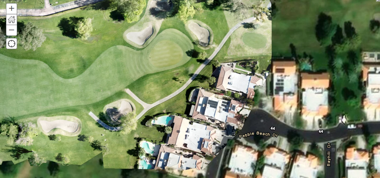
ESRI Map Integration with Unleash live
One of Unleash live's powerful features is the ability to automatically generate Orthomosaic maps from a drone flight and overlay these Orthomosaic maps over standard low-resolution satellite imagery provided by Google, open street maps, etc. This feature is useful, allowing high-resolution scans of ongoing construction projects, land for potential development, or anything you can fly a drone over. However, as many cities and enterprises rely on Esri’s ArcGIS mapping software, we decided to integrate our Unleash live-generated Orthomosaic maps straight into Esri. We do this via live sync across the two platforms—there is no need for the user to export and import the maps. This blog post shares a bit of our journey while building this fantastic capability together with our partner, Esri. Map Tiles Unleash live generates and displays high-resolution, large-scale Orthomosaic maps using tiles. Maps on the internet generally follow the “Tiled Web Map”, or “Slippy Map” format. This prevents unnecessary load — both on the network and memory — as only parts of the map currently required are loaded. The "Slippy" map format consists of a simple folder hierarchy, with the top-level directory containing the zoom level ( with 0 being the topmost i.e. the earth), the next subdirectory containing the “x”/Column tile, and finally, a 256x256 pixel image containing the “y”/Row tile — for example: tiles/0/0/0.png These tiles are usually served at a URL in the format: subdomain.domain.com/mapType/{level}/{col}/{row}.png A map front end calculates which tiles it needs based on the zoom level and location of the viewport, requests those tiles, and then displays them. Easy. Not so fast As with everything on the internet, multiple standards exist for storing and requesting map tiles. Unleash live uses the Google/OpenStreetMap standard, where tiles are stored in the format: Tiles/{zoom level}/{x/col}/{y/row}.png Esri expects tiles in the same format, but with the row reversed. This is refer
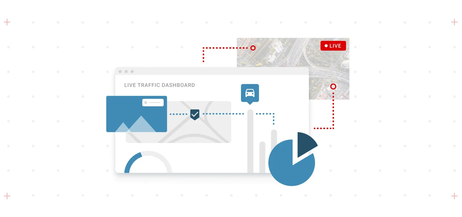
Live Esri Dashboards - A Powerful Integration for Real-Time Insights
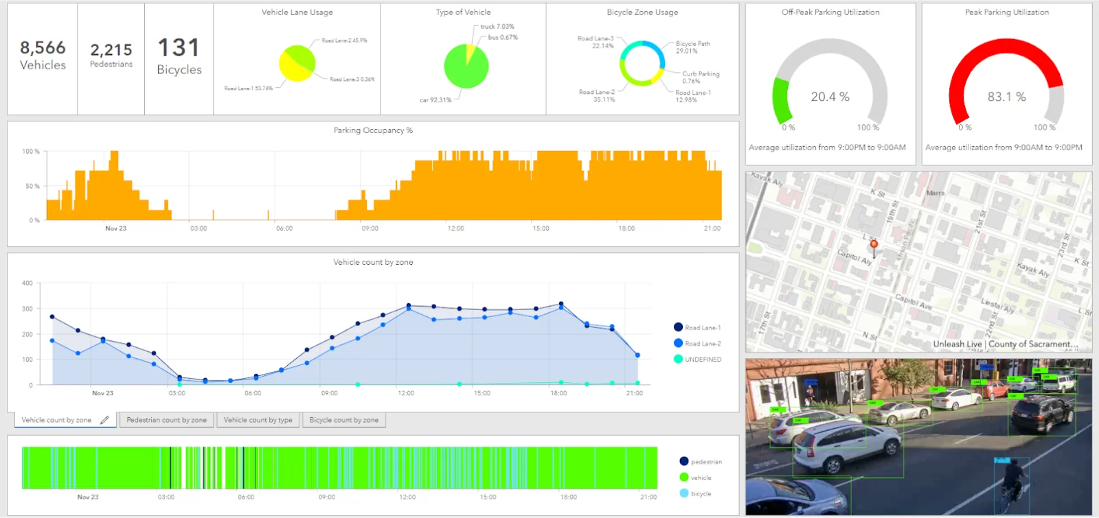
The Unleash live platform is a robust tool that applies AI computer vision models to live camera feeds, enabling high-performance analysis of HD video streams at up to 60 fps in real-time. This technology offers energy, utilities, transport, resource and infrastructure owners such as airports and public safety authorities unparalleled insights into their operations. Unleash live not only performs live streaming but also captures meaningful data using hundreds of AI Apps within the platform. These can be visualized to extract valuable insights, empowering our customers to build custom insights from powerful camera analytics. These insights cover critical use cases such as: Crowd movement Traffic flow Traffic congestion Zone utilization Parking utilization Curbside management Queue analysis Multi-modal transport analysis Security zone breach analysis And many many more. Live Customer Dashboard for Parking Violations Esri’s ArcGIS online provides state-of-the-art dashboards to display such data in real-time. This blog post provides a high-level overview of how we integrated Unleash live AI analytics with Esri Dashboards to enhance our customers’ decision-making processes. To learn more about a real-world application, check out our partnership with the City of Sacramento, California, USA. Live customer dashboard for parking violations Online offers state-of-the-art dashboards to display such data in real time. This blog post shares a high-level overview of how we integrated Unleash live AI. Analytics with Esri Dashboards and how it improves our customer’s decision-making. If you want to learn more about a real-world problem we solved, read more about our partnership with the City of Sacramento, California, USA. The Raw AI Data Challenge Unleash live can perform near to zero latency live stream and process the stream via AI and Machine learning technology in real time over the cloud or Edge with maximum inferences per second, generating a tremendous amount of information
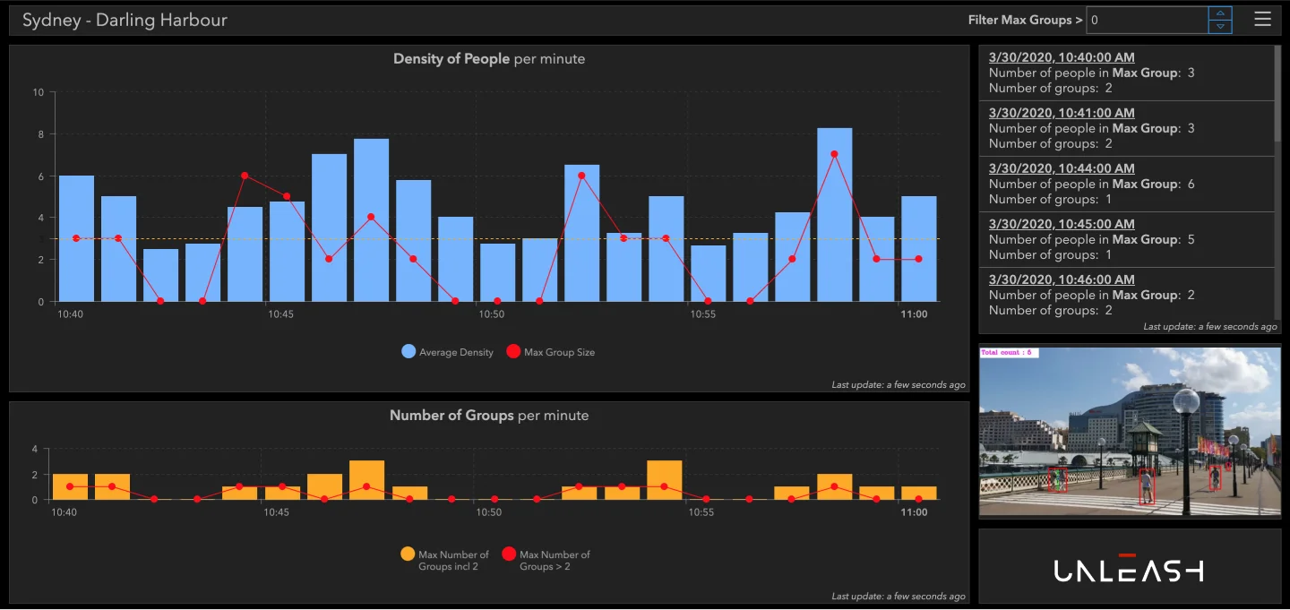
Replacing Fear with Credible Data
More frightening than the virus is the panic that it causes. “A mixture of miscalibrated emotion and limited knowledge,” argues psychologist David DeSteno in an editorial for The New York Times. We’ve seen panic buying and other forms of irrational behavior worldwide, leading to shortages and slow decision-making. In part, this panic is driven by a significant increase in demand for information and a relative lack of credible data to meet the demand. Like all supply-demand curves, audiences are turning their attention to more spurious sources, compounding the issue for authorities and bodies making decisions. Social Distancing is the single most effective action to stop the spread of #covid19, and yet the only blunt tool available to authorities (till now) is strict mandates to stay at home with devastating consequences for communities and economies. Many people seem to opt to ignore these rules. On Monday, the 30th of March, a large crowd gathered in New York to watch the US Navy hospital ship “Comfort,” which was arriving to aid the city with the ongoing threat of coronavirus. Similarly, in Australia, large crowds of backpackers took to the Beaches, sharing public showers and changing rooms, ignoring the Government's recommendations to stay at home and practice Social Distancing. One of the main challenges right now is panic-buyers spreading the coronavirus as they queue up in stores. Acquiring real-time, actionable data about where people are, their distance from one another, and their movements is a topic that our democratic societies 12 weeks ago would consider an unacceptable infringement on civil liberties. {{cta('5bd7c63a-783f-47bc-916d-248aa8bb3b05')}} Unleash live during Covid. In China, the application of computer vision has taken a darker, more draconian path. However, in our liberal Western societies, we have a choice in how we apply this technology to help protect ourselves and our families from the virus while also maintaining the principles by which
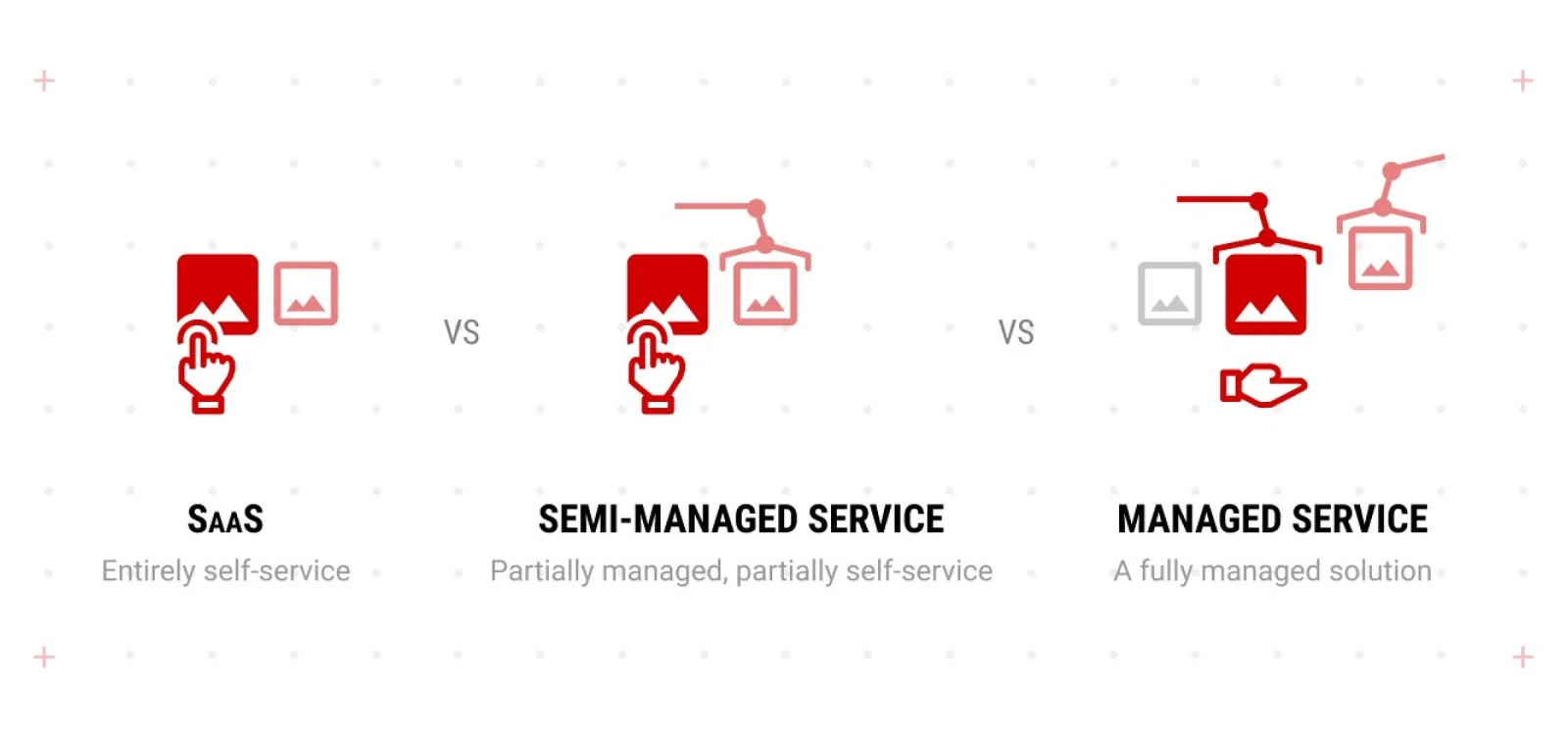
Selecting the Best Deployment Method
Our customers tell us that we make it easy to get started. You can get started in 3 ways: Fully Managed Service, Software Service, or complete Self-Service.
Data Insights Delivered in an Actionable Format
At Unleash live, we believe that data's true value lies in the insights it generates. We're committed to helping businesses quickly transform data into actionable insights.
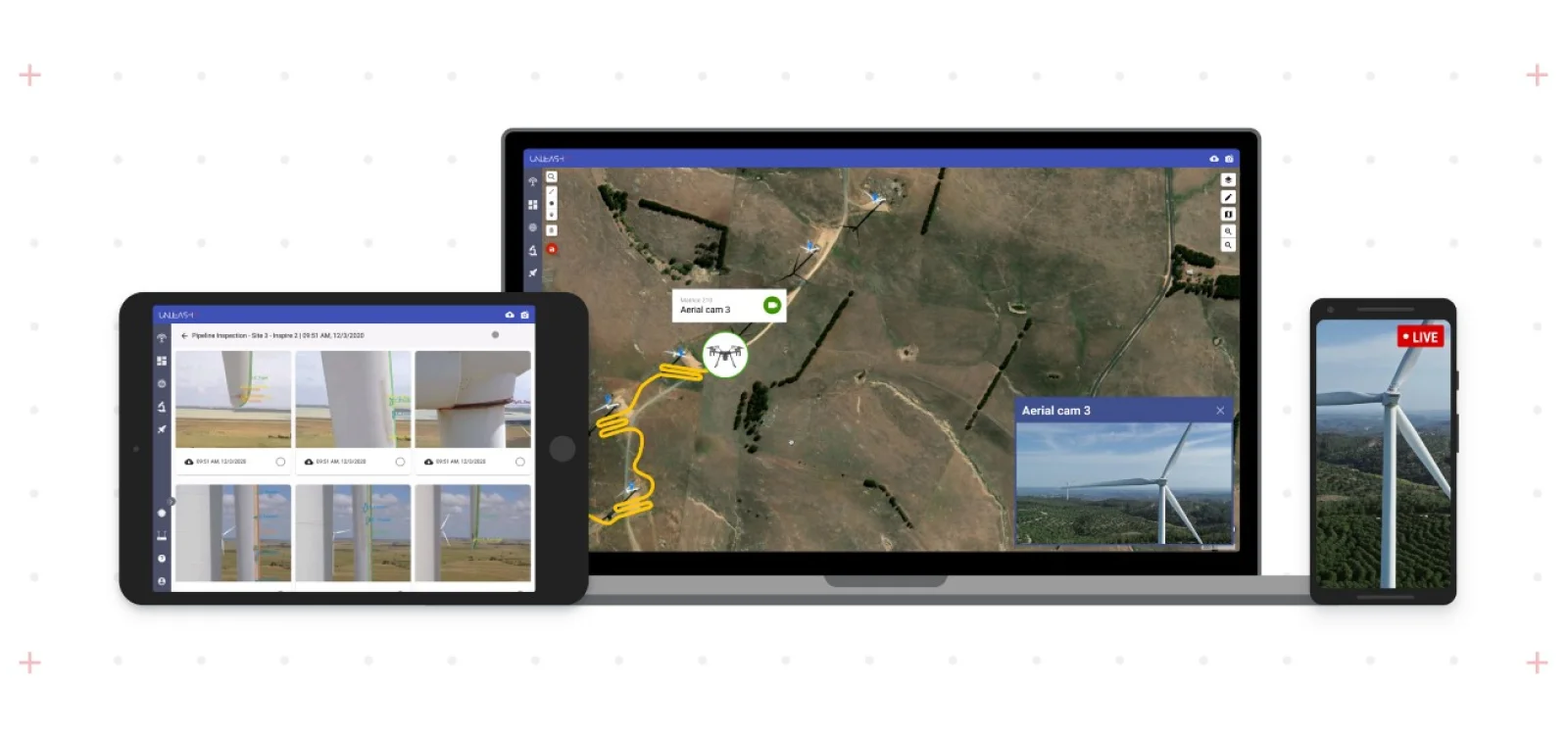
Wind Turbine Blade Automated Inspections
Aging is a fact of life. For wind farm operators, this is an increasingly important challenge to grapple with. Many data sources point to a direct correlation between asset age and performance. This is especially true for wind turbine blades.

Lidar vs. Photogrammetry - What’s the difference?
Drones get all the limelight, mainly due to their dazzling photography and video, however, Enterprises are now into the full thrust of using this visual data for actionable insights.

Ensuring Privacy, Security and Data Ownership with Unleash live
At Unleash live, our core business revolves around live streaming video with visual analytics, which naturally raises questions about privacy, data security and data ownership. We've built our platform on simple yet robust principles, with privacy by design at the heart of our offering to ensure transparency and clarity for our customers.
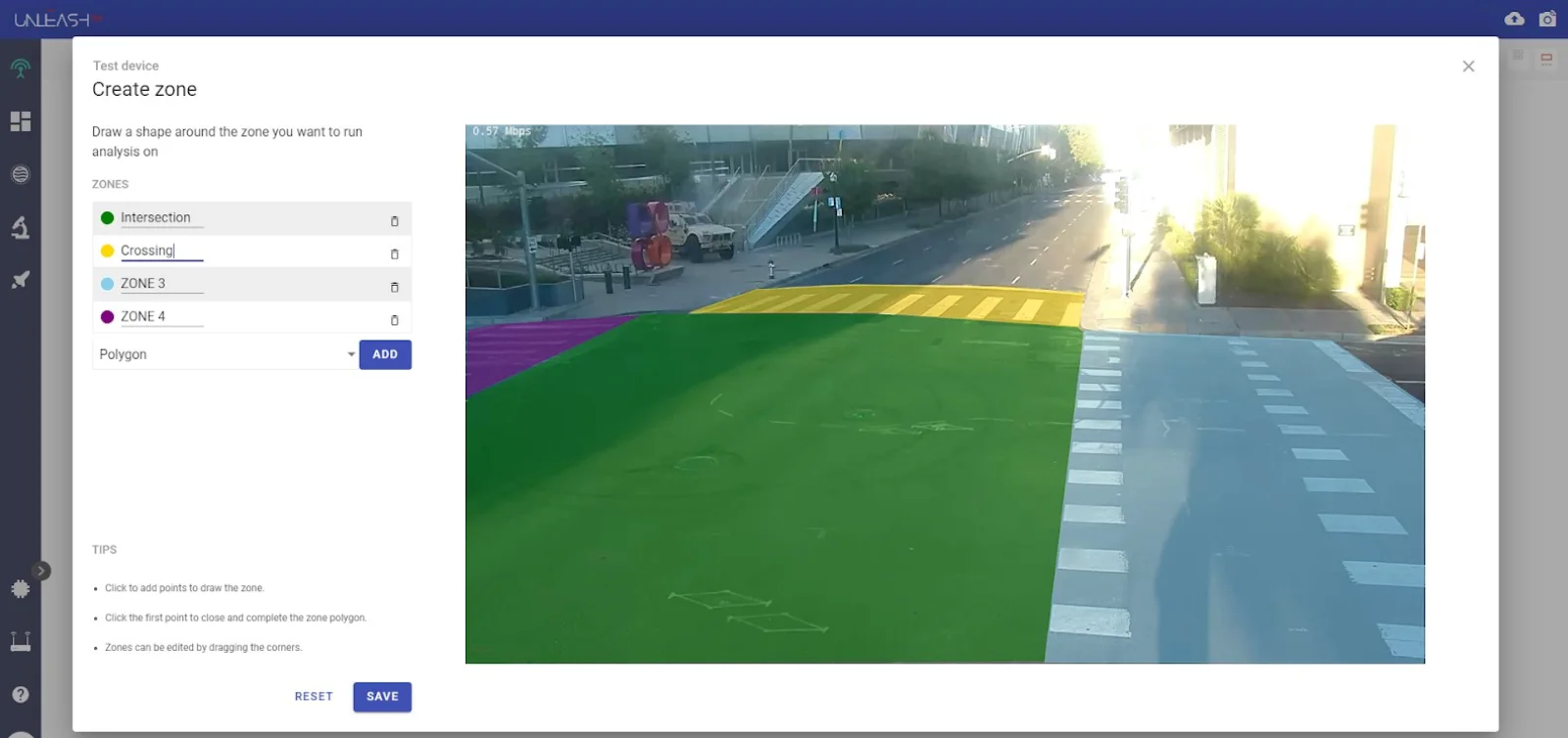
Data Capture - Measuring Reality with Accuracy
City planners, security personnel, emergency services, and police authorities regularly require the ability to measure the movement of people and vehicles in a given environment, either for real-time response or for data collection to make more informed decisions.
Inspect Remotely with Live Video
Remote inspections with live video collaboration have become increasingly popular since 2019. Companies are adopting virtual solutions to ensure business continuity, maintain supply chains, deliver operational timelines, and, most importantly, reduce the risk of exposure.